INDIAN ARMED FORCES CHIEFS ON OUR RELENTLESS AND FOCUSED PUBLISHING EFFORTS

The insightful articles, inspiring narrations and analytical perspectives presented by the Editorial Team, establish an alluring connect with the reader. My compliments and best wishes to SP Guide Publications.
"Over the past 60 years, the growth of SP Guide Publications has mirrored the rising stature of Indian Navy. Its well-researched and informative magazines on Defence and Aerospace sector have served to shape an educated opinion of our military personnel, policy makers and the public alike. I wish SP's Publication team continued success, fair winds and following seas in all future endeavour!"

Since, its inception in 1964, SP Guide Publications has consistently demonstrated commitment to high-quality journalism in the aerospace and defence sectors, earning a well-deserved reputation as Asia's largest media house in this domain. I wish SP Guide Publications continued success in its pursuit of excellence.


- MoD initiates comprehensive review of Defence Acquisition Procedure 2020, pushes for defence reforms
- G7: The Swansong
- Kalinga Connect: South Asia to Polynesia
- Must Credit DRDO for Operation Sindoor, now what is next for defence R&D?
- The layered Air Defence systems that worked superbly, the key element of Operation Sindoor
- Operation Sindoor | Day 2 DGMOs Briefing
- Operation Sindoor: Resolute yet Restrained
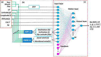
Artificial Neural Networks Ionospheric Model (ANNIM)
 |
The Author is Former Director General of Information Systems and A Special Forces Veteran, Indian Army |
Tracking the variability of the Ionosphere is important for communication and navigation. The ionospheric variability is greatly influenced by solar originated processes and the neutral atmosphere origin. The ionosphere extending from 60 km to about 1000 km altitude, plays a major role in aiding long distance HF (3 to 30 MHz) communications as well as in the deteriorating performance of satellite radio systems in the VHF (30 to 300 MHz), UHF (300 to 3000 MHz) and even higher frequency bands. The ionosphere influences radio propagation in which the radio refractive index of ionosphere, interaction of radio waves with ionosphere and reflection of radio waves come into play.
The long, relatively unhindered travel of the GPS signal through the virtual vacuum of space too changes as it passes through the earth's atmosphere. Through both refraction and diffraction, the atmosphere alters the apparent speed and, to a lesser extent, the direction of the signal. The ionosphere has layers sometimes known as the mesosphere and thermosphere but neither of that are themselves composed of D, E, and F regions extending 50-90 km, 90-120 km and 120-1000 km respectively. Neither the boundaries between these regions, nor the upper layer of the ionosphere, can be defined strictly. D region has almost no effect on GPS signals and E region has slight but it can scintillate the GPS signal. However F region affects propagation of electromagnetic signals the most. The ionosphere is also not homogeneous. Its behavior in one region of the earth is liable to be unlike its behavior in another. For example, ionospheric disturbances can be particularly harsh in the Polar Regions. But the highest Total Electron Value (TEC) values and the widest variations in the horizontal gradients occur in the band of about 60° of geomagnetic latitude. That band lies 30° north and 30° south of the earths magnetic equator. Severity of the ionospheres effect on a GPS signal depends on the amount of time that signal spends traveling through it. A signal originating from a satellite near the observers horizon must pass through a larger amount of the ionosphere to reach the receiver than does a signal from a satellite near the observers zenith. In other words, the longer the signal is in the ionosphere, the greater the ionospheres effect on it.
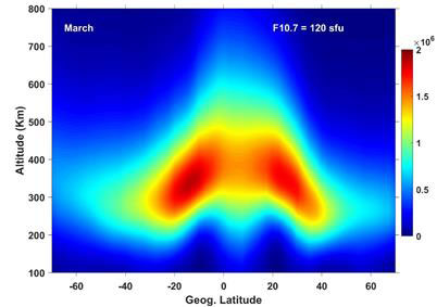
The good news is that now researchers from Indian Institute of Geomagnetism (IIG), Navi Mumbai have developed a new Artificial Neural Network based long-term Ionospheric Model (ANNIM) using long-term ionospheric observations to predict the ionospheric electron density and the peak parameters. Artificial Neural Networks (ANNs) replicate the human brain or biological neurons to solve problems like pattern recognition, classification, clustering, generalisation, linear and non-linear data fitting, and the like. The researchers developed the ANNIM by using an extensive database consisting of nearly two decades of global Digisonde (an instrument that measures real-time on-site electron density of the ionosphere by sending the radio frequency pulses), Global Navigation Satellite System (GNSS) radio occultation and topside sounders observations. These datasets were processed with various quality control measures to eliminate spurious data points (outliers) and prepared for the training. Day number, Universal Time, latitude, longitude, F10.7 index (responsible for Photo-ionization), Kp (represents the disturbed space weather conditions), magnetic declination, inclination, dip latitude, zonal and meridional neutral winds were taken as inputs in the study. The target (output) of ANNs is the electron density as a function of altitude for any given location and time. The data was trained with the ANNs using high-performance computer at IIG to develop the ANNIM. The ANNIM predictions done by the IIG team matched with the incoherent scatter radar and the satellite in situ electron density observations. Further, the ANNIM successfully reproduced large scale anomalies of the ionosphere. The ANNIM also captured the general morphological features of the ionosphere during the disturbed space weather periods, such as geomagnetic storms which occurs when the magnetic cloud originated from Sun (known as Coronal Mass Ejection (CME)) interacts with the Earths magnetosphere.
The ANNIM developed by IIG researchers can be utilised as a reference model in ionospheric predictions and has potential applications in calculating the GNSS positioning error. It would have a wider impact, ranging from accurate aiming on enemy targets to scientific research in space weather. According to Dr S. Tulasiram from IIG, one of the two primary researchers, This development is crucial for armed forces as, over the past few years, Indian Armed Forces have, like all militaries, sought pinpoint accuracy to minimise collateral damage in targeting enemy positions. Although several fighter jet and other missile systems have been fitted with highly-accurate navigation systems, few weapons in service can yet take advantage of this model, adding, Better ionospheric modeling will yield better accuracy of positioning in satellite based navigation. The current ionospheric model (AMMIM) accuracy is significantly better compared to other ionospheric models used in single frequency GPS users. ANNIM is another feather in Indias cap.
SP's Land Forces - CURRENT ISSUE