


The insightful articles, inspiring narrations and analytical perspectives presented by the Editorial Team, establish an alluring connect with the reader. My compliments and best wishes to SP Guide Publications.

"Over the past 60 years, the growth of SP Guide Publications has mirrored the rising stature of Indian Navy. Its well-researched and informative magazines on Defence and Aerospace sector have served to shape an educated opinion of our military personnel, policy makers and the public alike. I wish SP's Publication team continued success, fair winds and following seas in all future endeavour!"

Since, its inception in 1964, SP Guide Publications has consistently demonstrated commitment to high-quality journalism in the aerospace and defence sectors, earning a well-deserved reputation as Asia's largest media house in this domain. I wish SP Guide Publications continued success in its pursuit of excellence.
China's advances in space and electronic warfare highlight India's urgent need for an independent, secure, and military-grade navigation system
 |
The Author is Former Director General of Information Systems and A Special Forces Veteran, Indian Army |

In 1999, the book '战论' in Mandarin language, which means 'Unrestricted Warfare' in English, was published in China. American Think Tanks were shocked when they translated it into English; who coined the term 'hybrid warfare'. Title of the English version of the book is 'Unrestricted Warfare: China's Master Plan to Destroy America'. That was 25 years plus ago. China has been working assiduously since to win wars before the war erupts – against the US particularly.
For the past decade, China has been working to cripple America's GPS (NAVSTAR), a 32 sattelite constellation 20,000-km above Earth, whose signals are easy to jam, spoof or hijack. China has deployed layered weaponry for this; ground-based jammers to anti-satellite (ASAT) weapons. Taking out the GPS would cripple all US military systems losing positioning, navigation and timing (PNT), plus cause global mayhem in commercial shipping, banking and other systems.
China has been working to cripple America's GPS (NAVSTAR). Taking out the GPS would cripple all US military systems losing positioning, navigation and timing (PNT), plus cause global mayhem in commercial shipping, banking and other systems.
The Chinese satellite, Shiyan-28B, launched on July 3, 2025, was undetectable by space tracking systems for six days, eventually spotted by the US on July 9 in an unusually low orbit. Is China experimenting with "stealth" satellites? In February 2025, China unveiled a deep-sea cable cutter, which can be a strategic asset in future wars; covertly slashing away deep-sea data cables (nervous system of the modern world – internet, military communications and the like), which carry 95 per cent of global data.

According to news reports of July 24, 2025, China has made a big leap in satellite communication by using a 2-Watt Laser to transmit data at speeds far outpacing Starlink; using a satellite operating at 36,000 km above Earth, a distance far greater than SpaceX's Starlink, which operates from only 550 km.
It was covered in these columns recently that indigenous startup 'QuBeats' is to develop a Quantum Positioning System (QPS) for the Indian Navy, Britain's National Physical Laboratory (NPL) is advancing optical clock technology to enhance precision and reliability in timekeeping; and American companies are innovating with technologies like magnetic navigation to provide alternative solutions to traditional GPS systems. For the militaries and the world, going GPS-free remains a distant future. But the fact remains that the Indian Government should designate IITs to conduct sustained research for developing alternates systems for the GPS.
China unveiled a deep-sea cable cutter, covertly slashing away deep-sea data cables (nervous system of the modern world – internet, military communications and the like), which carry 95 per cent of global data.
China's BeiDou Navigation Satellite System (BDS) has global coverage with 45 operational satellites in orbit, Russia has 'GLONASS', the European Union 'Galileo', and India has 'NavIC' (Navigation with India Constellation). NavIC is a regional GPS system that was launched after the US "switched-off" its GPS during the 1999 Kargil Conflict to prevent the India Navy from Blockading Karachi harbour.
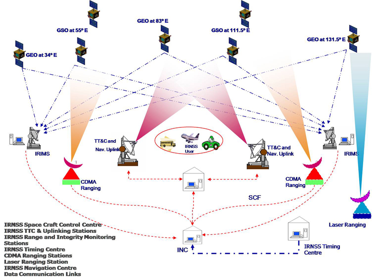
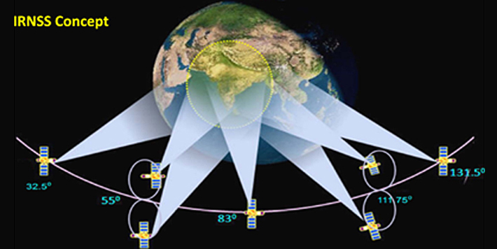
NavIC, operational since 2018, is based on the Indian Regional Navigation Satellite System (IRNSS); seven satellites in geostationary and geosynchronous orbits. NavIC was designed to provide positioning accuracy of better than 20 meters across India and a 1,500-km region around it – supporting civilian and restricted (military) services with encrypted signals. However, only four satellites of IRNSS are presently functional to provide positional data The Parliament was informed during the current Monsoon Session that ISRO is to launch three more navigation satellites; NVS-03 by end 2025, plus NVS-04 and NVS-05 after that with a gap of six months. The regional coverage of NavIC, its regional coverage dual-use nature and ISRO's primary focus on civilian and scientific missions limits its suitability for exclusive military requirements, which certainly needs sub-meter accuracy in modern-era warfare.
The role of the India Military is expanding beyond traditional Out of Area Contingencies (OOAC), to meet emerging challenges in the Indo-Pacific, while retaining strategic autonomy. Moreover, NavIC doesn't cater to the military's increasing participation in multilateral exercises, whether of Quad partners, or with other nations around the world, as well as deployment in potential conflict zones where interoperability is vital. Also, the regional reach of NavIC doesn't cover long-range missions of the Indian Navy's P-8I and other reconnaissance aircraft, as well as missions of IAF's fighter jets beyond South Asia. In addition, the shared infrastructure of NavIC makes it prone to the possibility of jamming, spoofing and hijacking by the enemy during or just before conflict in order to cripple both military and civilian users.
There are calls for a dedicated GPS for the Indian Military, independent of NavIC, offering global coverage, enhanced encryption and resilience against enemy's electronic warfare
The Indian Space Research Organisation (ISRO) no doubt is doing a wonderful job. However, its focus will of necessity remain on civilian and dual-use programmes; missions to the Moon, Mars, Venus, space exploration for science research, as well as commercial launches. At the same time, the Indian Military's bandwidth requirements will keep increasing exponentially because of the nature of future operations and the type of data it would need to transmit. This includes real-time video feeds from drones, large data transfers for situational awareness, and secure communication channels, all of which demand high-capacity, reliable, and secure connections. The increasing use of SATCOM and of Internet of Things (IoT) devices on the battlefield will further increase the demand for bandwidth.
There are calls in the media for a dedicated GPS for the Indian Military, independent of NavIC, offering global coverage, enhanced encryption and resilience against enemy's electronic warfare; ensuring secure, real-time positioning, navigation and timing (PNT) for a wide range of applications, including missile guidance, unmanned aerial vehicles (UAVs) and network-centric warfare involving platforms. A dedicated military GPS could incorporate anti-jamming technologies, like narrowband signals and advanced encryption to counter threats from enemy electronic warfare systems. The need for an independent military GPS is further driven by regional security dynamics, including China's partnership with Pakistan and Bangladesh.
The need for an independent military GPS is further driven by regional security dynamics, including China's partnership with Pakistan and Bangladesh.
The recommendation in media is that the dedicated military GPS be developed in public-private partnership by ISRO, drawing attention to companies like Tata Advanced Systems Limited (TASL) and emerging startups like Skyroot Aerospace and AgniKul Cosmos having demonstrated capabilities in satellite manufacturing and launch vehicles, as well as the contribution by Public Sector Undertaking Bharat Electronics Limited (BEL) in defence electronics. It may also be recalled that Mumbai-based startup 'Exseed Space' became the first Indian private firm to have a satellite in space, named 'ExseedSAT-1 in December 2018, and Bengaluru-based private firm 'Pixxel' launched the first private constellation of earth-imaging satellites, named 'Firefly', in January 2025 – a constellation hyperspectral satellites with high-resolution capabilities. There is no doubt that India's private sector, which has seen rapid growth in aerospace and defence innovation, offers a solution to accelerate development and reduce costs.
Considering that a dedicated Indian Military Navigation System was required yesterday, we need to develop it without loss of further time. The Department of Space (DOS), free of bureaucratic red-tape and functioning directly under the Prime Minister, could be tasked to coordinate this in conjunction with the Ministry of Defence (MoD), ISRO, DRDO and private players; laying out the required policy framework and timelines for development. With the priority needed for developing a dedicated Indian Military Navigation System, and the fact that the US GPS (NAVSTAR) provides global coverage with a constellation of 32 satellites, part of the 52 military satellites being launched by 2029 under the $32 billion Space Based Surveillance-III (SBS-III) program could be used for a dedicated Indian Military Navigation System, with the private sector duly integrated.